


Geological Resristivity Surveys
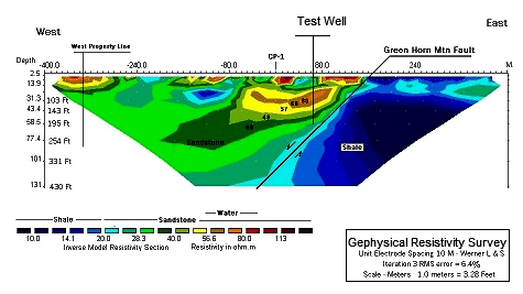
If the site is virgin and does not have any history of it than the site is first marked on the 1:50,000 scale topographic sheet. The physical terrain of the site is first verified and if the need be the site is visited before conducting the survey. The resistivity survey is based on the basic principle that every individual matter has got its own resistance (electrical) and the nature of the matter can be interpreted based on this conductance or resistance. In order to eliminate the failure rates, potential sites are pinpointed with the help of Geophysical equipment that can investigate and infer the type of formations to a depth of 1500 ft. depth and the interpretation is done using latest computer software like the one developed for Schlumberger array or any other alternate kind of electrode separation suitable based on the terrain. The interpretation of the data from the survey gives a fair idea of the formations below and the quantity of water that can be tapped. Deputation of Rig: Based on the formations as depicted in the survey the type of rig which is to be deputed is decided. There are mainly the following types of drilling methods. Reverse circulation drillingDirect circulation drillingCable tool drilling or percussion type of drillingDTH (Down the Hole ) drillingOrdex The other kind of drilling methods are either adopted version of these above mentioned methods or are improvised combination of these kinds of drilling like dual rotary method (Combination of DTH & Casing drilling), Combination Rig ( Direct rotary rig combined with Percussion drilling) etc.
Geophisical Investigation Services
We have built our stance by rendering services that have not only offered value for money but have also met the specific requirements of our clients. Our ability to understand their requirements have enabled us a position of leading service provider in this industry. Known for reliability, our services include Ground Strengthening Designs, Seepage Control Designs, etc.A related geophysical method, induced polarization, measures the transient response. The technique evolved from techniques of electrical prospecting that predate digital computers, where layers or anomalies were sought rather than images. Early work on the mathematical problem in the 1930s assumed a layered medium. Tikhonov who is best known for his work on regularization of inverse problems also worked on this problem. He explains in detail how to solve the ERT problem in a simple case of 2-layered medium. During the 1940s he collaborated with geophysicists and without the aid of computers they discovered large deposits of copper. As a result, they were awarded a State Prize of Soviet Union. When adequate computers became widely available the inverse problem of ERT could be solved numerically, and the work of Loke and Barker with the advancement in the field of Electrical Resistivity Tomography (ERT) from 1D to 2D and now-a- days 3D, ERT has explored many fields. The applications of ERT include fault investigation, ground water table investigation, soil moisture content determination and many others. In industrial process imaging ERT can be used in a similar fashion to medical EIT, to image the distribution of conductivity in mixing vessels and pipes. In this context it is usually called Electrical Resistance Tomography, emphasizing the quantity that is measured rather than imaged.